Bentley’s IoT Cloud Solution Enables Project Team to Reliably Share Data and Cost Effectively Enhance Asset Management
Restoring road safety after a thousand-year flood
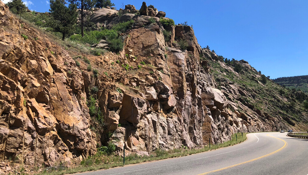
In early September 2013, historic rainfall and flooding created widespread damage in parts of Colorado. This 1,000-year weather event caused USD 2 billion in property loss and extensive damage to local and state infrastructure, including many roads and bridges. One of those affected was US Highway 36, a key artery for tourists, trucks, and locals. One of the state’s busiest highways, it runs from Estes Park, Colorado, near the entrance to Rocky Mountain National Park, to the city of Boulder and east toward the Kansas border. The damage closed US 36 for two months, resulting in very long detours for motorists.
While the road was subsequently repaired and re-opened, the rainfall and flooding had deeply destabilized surface material on the road cuts along its corridor. Portions of US 36 navigate steep, hard rock slopes that presented a risk of rockfall hazards to the traveling public even before the flood. Following the weather event, the soil beneath many large and medium-sized boulders above the road washed away due to surface erosion, increasing the likelihood of serious rockfalls that put people, vehicles, and road infrastructure at risk.
Fast facts
- In 2013, historic rainfall and flooding caused USD 2 billion in property loss and extensive damage to Colorado infrastructure, including roads.
- Damage caused to US Highway 36, a key artery for tourists, trucks, and local traffic, was repaired but the road remained subject to rockfall caused by erosion.
- Shannon & Wilson needed to improve ground monitoring in a remote area with poor cellular reception while using legacy sensors.
Difficulties with site access and communications
To ensure the safety of the traveling public and the operational state of the highway, the Colorado Department of Transportation (CDOT) decided they needed to upgrade the existing monitoring system to provide remote and real-time access to the rock slope’s performance at key locations identified through risk analysis. They retained engineering consulting firm Shannon & Wilson to design and install a state-of-the-art monitoring system to alert CDOT’s team to slope movement. Headquartered in Seattle, Washington, Shannon & Wilson provides integrated geotechnical engineering, engineering geology, environmental, and natural resource services worldwide and is a leader in providing consulting services to DOTs around the nation.
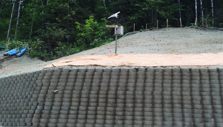
While evaluating the area, the design team realized the project brought unique challenges. Much of US 36 travels along a rugged landscape with limited access. Many of the new monitoring devices could only be installed with the help of professional ropes crews. In May 2018, more than 30 previously installed crack meters were automated at two sites approximately 3,000 linear feet apart along the US 36 corridor, near Lyons, Colorado. Given the difficulty of the initial crack meter installation, Shannon & Wilson decided to incorporate the existing sensors in their new system. Additionally, the remote site does not have access to a grid-based power source, and the cell reception at the remote location is intermittent to poor. Shannon & Wilson needed a solution that could operate without connections to the electrical grid or a local wired internet service.
The sensemetrics connectivity devices provide self-sustained power via solar panels and integrated rechargeable batteries to all automation devices and sensors on the project.
State-of-the-art, real-time condition monitoring
To address the challenges of the site, Shannon & Wilson selected sensemetrics, Bentley Systems’ Infrastructure Internet of Things (IIoT) cloud platform, to collect and manage the data from the suite of geotechnical and environmental sensors. They used sensemetrics’ intelligent communication IIoT devices, supporting both LPWAN and cellular communication, to easily deploy a dynamic and resilient automation system for the project. The sensemetrics connectivity devices provide selfsustained power via solar panels and integrated rechargeable batteries to all automation devices and sensors on the project. The installed IoT devices and connected sensors along the project area are now managed using cloud-connected tools and mobile applications accessible to system administrators wherever they are.
With this system in place, CDOT personnel are alerted when slope deflection becomes significant enough to present an increased risk for rockfall. Realtime insights allow CDOT to respond to developing issues, make informed decisions, and take the necessary measures to respond accordingly. Additionally, the implementation of the cloud-based monitoring platform has improved asset management and situational awareness in the remote location destabilized by historic rains.
Overcoming common monitoring challenges for Dots
With this system in place, CDOT personnel are alerted when slope deflection becomes significant enough to present an increased risk for rockfall. Realtime insights allow CDOT to respond to developing issues, make informed decisions, and take the necessary measures to respond accordingly. Additionally, the implementation of the cloud-based monitoring platform has improved asset management and situational awareness in the remote location destabilized by historic rains.
With this system in place, CDOT personnel are alerted when slope deflection becomes significant enough to present an increased risk for rockfall. Realtime insights allow CDOT to respond to developing issues, make informed decisions, and take the necessary measures to respond accordingly. Additionally, the implementation of the cloud-based monitoring platform has improved asset management and situational awareness in the remote location destabilized by historic rains.
ROI
- The continual data provided by sensemetrics has improved safety and enhanced asset management along US 36.
- Data from the sensors provide a longerterm picture to understand ground and rock movements, helping prevent damage and ensure safety
- The monitoring system was applied to CDOT’s legacy sensors, saving a significant amount of time and money.